| |
|
|
|
RELATED LINKS
Eyes on the Bomb
Eyes on Saddam
U.S. Satellite Imagery, 1960-1999

|
Washington, DC, November 27, 2012 – In the forty years since the first launch of a commercial imagery satellite – LANDSAT – in 1972, U.S. official policy has shifted dramatically from imposing significant limits on their capabilities to permitting U.S. firms to orbit high-resolution satellites with significant intelligence-gathering capacities. According to declassified documents posted today by the National Security Archive, internal debates within the government have focused both on the risks of adversaries exploiting such commercial platforms and on the potential benefits for the U.S. of having access to unclassified imagery. The risks in recent years include the use of Google Earth by terrorist groups to identify targets for attack; the benefits range from being able to observe foreign nuclear sites to monitoring human rights violations. Over time, U.S. presidents have come to recognize that they cannot prevent foreign entities from developing extremely high-resolution satellite equipment. This realization has contributed to drastic swings in U.S. policies, aimed not only at enhancing the national security but at promoting the commercial competitiveness of American companies abroad. The 39 documents posted today were obtained via Freedom of Information Act requests, archival research and a variety of websites. They focus on virtually every issue associated with commercial satellite imagery over the last four decades. Among the highlights are records relating to:
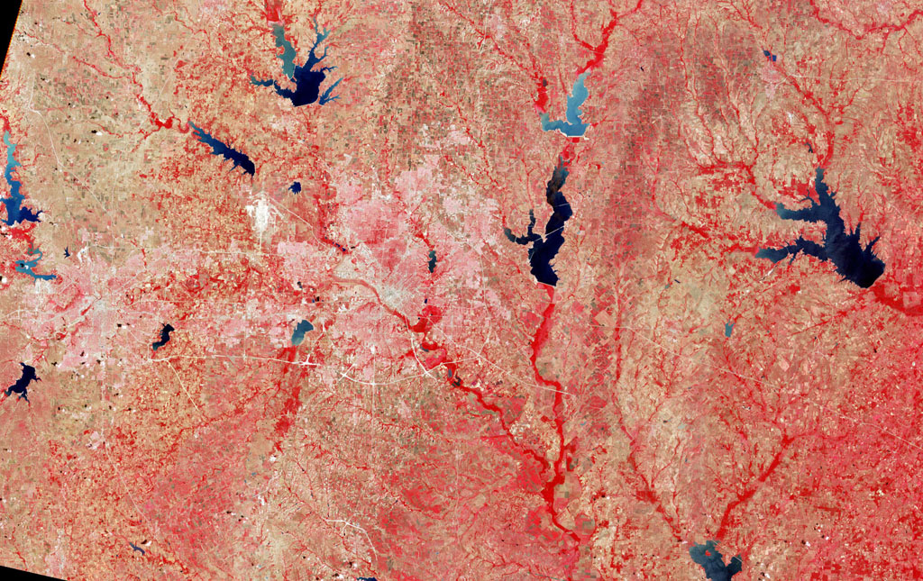
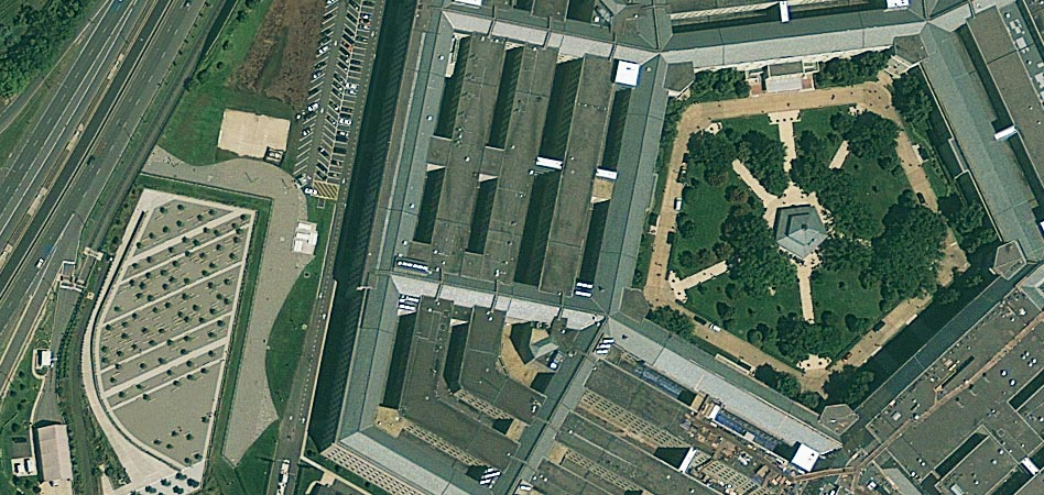
* * * Commercial Satellite Imagery and National SecurityBy Jeffrey T. RichelsonSatellite imagery of foreign targets that could be exploited for intelligence purposes originated as a highly-classified activity. Until 1970 – when the People's Republic of China orbited its first photo-reconnaissance satellite – it was a capability possessed only by the United and Soviet Union. All of those nations restricted access to the product of their space reconnaissance operations to a select number of cleared individuals (which included, at least in the case of the United States, some in the governments of allied nations). In 1972, the United States orbited what was initially known as the Earth Resources Technology Satellite (ERTS) and then as LANDSAT. LANDSAT satellites, the most recent version being LANDSAT 7, have produced both black-and-white and multispectral imagery of low resolution. For national security reasons, the United States initially sought to limit the ability of LANDSAT and any other commercial satellites that might be developed and restricted resolution to 33 feet or worse. Although 33 feet was better than the original resolution of the very first U.S. KEYHOLE cameras – the KH-1 – which produced images with about 35 foot resolution, it was far inferior to U.S. capabilities in the early 1970s and beyond. In 1986, the French orbited the first SPOT (Systeme Probatoire d'Observation de la Terre) satellite, with 33-foot resolution for black and white images. The quantum improvement in capabilities from LANDSAT made it attractive to both governments without their own satellite reconnaissance systems and outside organizations which hoped they could exploit the imagery of targets around the world to provide new information on foreign military programs and activities. During a January 1989 conference former Deputy Director of Central Intelligence Bobby Inman described the quality of SPOT's imagery as "outstanding." The conference went on to explore, inter alia, the potential (sometimes limited) of SPOT imagery for monitoring nuclear tests, proliferation, and arms control compliance. By that time, there were also concrete examples of the uses of SPOT imagery for such purposes - including images of CSS-2 missile sites in Saudi Arabia. In addition, the Defense Department employed SPOT imagery to provide imagery of Soviet facilities in its unclassified Soviet Military Power publications - including images of naval bases, airfields, and relocation centers for senior officials. 1 During the same period some were also exploring the idea of a "MEDIASAT" that would provide higher-resolution imagery to news organizations. That topic became the subject of a detailed technical memorandum by the congressional Office of Technology Assessment (Document 5). In the late 1980s and early 1990s the Soviet Union started offering for sale some of the imagery produced by its military reconnaissance satellites, specifically those that carried the KFA-1000 camera which sometimes produced images with a resolution of about 20 feet.2 The possible utility of such imagery for both government and non-government organizations was explored in a 1994 report (Document 11) by the Defense Mapping Agency (subsequently incorporated into the National Imagery and Mapping Agency, since renamed the National Geospatial-Intelligence Agency). Since that time there have been dramatic changes with regard to the availability and variety of commercial satellite imagery. U.S. policy has changed drastically, removing legal roadblocks to the development and operation of commercial satellites with resolution in the area of 1-2 feet. That change was in part motivated by the recognition that commercial imagery satellites were proliferating and that many were being developed by other nations or firms outside of the United States, which had no obligation to adhere to U.S. policy on resolution limits. In addition, recent foreign satellites have carried radar imagery systems which allow imagery to be obtained at night or in the presence of cloud cover (Document 30, Document 36). Thus, in 1994 the U.S. began the process of drastically revising its policy on commercial imagery satellites from that first established during the Jimmy Carter administration (Document 3, Document 4), which involved both open Congressional hearings in February and a secret presidential directive in March (Document 10).3 In an explanatory memo (Document 7) to President Bill Clinton, National Security Adviser Sandy Berger noted that the directive "represents a significant change in current policy by allowing the expansion of the commercial sale of images taken from space and the export of such systems themselves. This policy is intended to open the way for US firms to compete aggressively in a growing international market." One consequence of the change in policy was the September 1999 launch, by Colorado-based Space Imaging (now GeoEye), of the IKONOS satellite, which returned images with a resolution of approximately 2.7 feet. GeoEye and Digital Globe, another American firm, have since orbited satellites (GeoEye-1, Worldview-1, and Worldview-2) with better resolutions – as good as 18 inches in the case of Worldview-2. A GeoEye-2 spacecraft, to be launched in late 2012, is projected to return images with a resolution of 13 inches.4 The imagery returned by those satellites has come to be used extensively by non-governmental organizations to explore a variety of human rights as well as military issues – including North Korean prison camps, atrocities in the Sudan, the monitoring of Russian and Chinese nuclear forces, North Korean and other nations missile deployments and the nuclear activities of a variety of nations – including Pakistan, North Korea, Iran, and Syria.5 From the earliest days of commercial satellite imagery – when it was restricted to LANDSAT – while there have been individuals or institutions who have viewed it largely with promise, others focused on the peril they believed it represented. One concern was that foreign intelligence organizations could exploit such imagery for strategic military intelligence, augmenting whatever capabilities that they possessed. Thus, in the early 1970s, two CIA studies (Document 1, Document 2) examined the ability of People's Republic of China or other nations to exploit LANDSAT. Some of that work was employed in making licensing decisions. Some were concerned that such satellites could be employed to undermine operational security – either by producing images of classified facilities (such as Area 51) or military operations in progress or about to occur - such as General Norman Schwarzkopf's "Hail Mary" maneuver that preceded the expulsion of Iraqi forces from Kuwait in February 1991. The problems and possible solutions were examined in a variety of studies, including theses for military educational institutions (Document19, Document 37). One solution, implemented by the National Imagery and Mapping Agency in the aftermath of the September 11, 2001 terrorist attacks, was to preemptively purchase all of IKONOS' capability to produce imagery of Afghanistan – so that images could be released only with the U.S. government's approval.6 More recently, there has been concern over the use of assets such as Google Earth by terrorist groups. By April 2006, the Director of National Intelligence's Open Source Center began monitoring use of Google Earth on jihadist websites. The center subsequently reported that in September 2006 "Al-Qaeda linked militants in Yemen exploded four car bombs in a failed attack on oil facilities, planned with the aid of Google Earth." (Document 23) At the same time, it became clear that commercial imagery could aid U.S. national security and civil agencies in the performance of their mission. Thus, civil satellite imagery was employed in Operations Desert Shield and Desert Storm. In 1996, it was reported that SPOT imagery was used to produce simulated 3-D images that conduct practice flyovers of Bosnia.7 In addition, such imagery, being unclassified, could be shared without restriction with foreign governments and organizations that would not be granted access to the product of U.S. intelligence satellite systems. It could also be used in releasing material to the public without restriction - which the Pentagon took advantage of, as noted above, in producing Soviet Military Power. In addition, such systems could be used to augment classified systems when the classified constellation was experiencing problems because of on-orbit failures or due to problems with satellite development. Thus, in 2002, Director of Central Intelligence George J. Tenet, in the face of problems with the Future Imagery Architecture program, directed increased use of commercial imagery (Document 20). That commercial imagery was envisioned as an essential part of U.S. national security strategy was evident in an April 2009 decision by President Barack Obama. He directed (Document 28) that in addition to procuring two classified electro-optical imagery satellites to provide intelligence in support of national security and other activities the U.S. should also invest in two commercial imagery satellites. An earlier plan (Document 26), which called for the National Reconnaissance Office to procure two commercial-class satellites, generated opposition from a variety of sources, and Congress denied funds to go forward. However, since then budget limitations have threatened to lead to cuts in the $7.3 billion Enhanced View program (Document 39a, Document 39b), serving as a catalyst for further consolidation of U.S. commercial imagery firms.8
DOCUMENTSDocument 1: Central Intelligence Agency, Probable Chinese Collection of U.S. Satellite Imagery, August 1973. Secret . Source: CIA Freedom of Information Act Release. Following up on an order, apparently placed on behalf of the People's Republic of China, for imagery from the Earth Resources Technology Satellite (subsequently renamed LANDSAT), this document examines the specifics of the request other PRC collection activities related to mapping, charting, and geodesy. It notes that "the ordered images could be used by the PRC in its missile targeting programs."
Document 2: Central Intelligence Agency, Strategic Intelligence from ERTS?: An Analysis of Digital Data on Soviet ICBM Sites, June 1975. Secret. Source: CIA Records Search Tool (CREST), National Archives and Records Administration II. This study examines, in detail, the potential for foreign nations, particularly the People's Republic of China, to exploit ERTS (LANDSAT) imagery for strategic intelligence purposes - including identification and targeting of cities, airports, port facilities, transportation routes, and offensive and defensive missile sites.
Document 3: Zbigniew Brzezinski, Presidential Directive/NSC-42, Subject: Civil and Further National Space Policy, October 10, 1978. Secret. Source: www.jimmycarterlibrary.gov. This directive defines the administration's space policy with regard to civil applications, including with respect to remote sensing.
Document 4: Zbigniew Brzezinski, Presidential Directive/NSC-54, Subject: Civil Operational Remote Sensing, November 16, 1979. Secret. Source: www.jimmycarterlibrary.gov. As its title indicates, this directive focuses specifically on civil remote sensing - including with respect to LANDSAT, private sector involvement, and international participation.
Document 5: Office of Technology Assessment, Commercial Newsgathering from Space: A Technical Memorandum, May 1987. Unclassified. Source: www.fas.org. This study, written well before the advent of high-resolution commercial imagery satellites but after the media's use of commercial imagery to cover several newsworthy events (including Chernobyl and the Iran-Iraq war), explores the possibility of a MEDIASAT - a commercial imagery satellite whose express purpose would be to provide imagery to media outlets. In addition to exploring potential value to the media, the study also addresses national security concerns and the issue of a MEDIASAT and the First Amendment.
Document 6: Major William K. James, Statement on the Defense Mapping Agency Uses of LANDSAT, June 26, 1991. Unclassified. Source: House Permanent Select Committee on Intelligence/House Science, Space and Technology Committee. This statement by the Director of the Defense Mapping Agency (which, in 1996, was merged with several other organizations to form the National Imagery and Mapping Agency) addresses DMA's use of LANDSAT data to produce maps, charts, and geodetic products as well as potential modifications to the system that would make it more useful for the production of those products.
Document 7: Samuel R. Berger, Memorandum for the President, Subject: US Policy on Foreign Access to Remote Sensing Space Capabilities, March 3, 1994, Secret. Source: www.fas.org. This memo, from National Security Adviser Sandy Berger, provides background for the president, who is being asked to approve a Presidential Decision Directive on foreign access to the products of commercial remote sensing systems. Berger notes that a number of issues forced the U.S. government to review its policies in the area, including the increasing use of space-based images by commercial entities and the proliferation of space-based remote sensing capabilities throughout the world.
Document 8: Regina A. Genton, Memorandum for Samuel R. Berger, Subject: PDD on Remote Sensing, March 9, 1994. Secret. Source: www.fas.org. This memo to National Security Adviser Berger notes two revisions to the draft PDD, which Berger wrote about to the president on March 3 (Document 7 ).
Document 9: Todd Stern to Mr. President, March 9, 1994. Secret. Source: www.fas.org. This memo to the president, from White House Staff Secretary Todd Stern, attached to Document 8, refers to Sandy Berger's memo (Document 7) recommending the president sign the presidential decision directive - which he notes would allow for expanded sales of images acquired from space. He also notes the roles of the Commerce and State Departments in sale and licensing arrangements.
Document 10: William J. Clinton, Presidential Decision Directive/NSC-23, Subject: US Policy on Foreign Access to Remote Sensing Space Capabilities, March 9, 1994. Secret. Source: www.fas.org. This directive revised U.S. policy toward foreign access to remote sensing data (particularly imagery) as well as remote sensing systems in response to the circumstances noted by Sandy Berger in his March 3 memo (Document 7). Its two major sections concern the licensing and operation of private remote sensing systems and the transfer of advanced remote sensing capabilities.
Document 11: Defense Mapping Agency, Report on the Evaluation and Procurement of Former Soviet Union Imagery and Materials, March 10, 1994. Unclassified. Source: Editor's Collection. This DMA report to the Congressional defense committees summarizes actions taken by DMA in response to legislation requiring it to obtain imagery and related materials from the Soviet successor states. The 45-page report examines material availability, priorities for acquisition, the process for dissemination, and the evaluation plan before the presentation of conclusions. It also includes Russian and French overhead images of the same unidentified site.
Document 12: Science Applications International Corporation, Final Report: Stability Implications of Open-Market Availability of Space-Based Sensor and Navigation Information, November 9, 1995, Unclassified. Source: Editor's Collection. This report summarizes seminar presentations at a U.S. government-sponsored conference that examined the opportunities and risks associated with the availability of satellite imagery, lessons from Desert Storm with regard to space control and strategic stability, and the motivations and activities of foreign nations in developing space-based imagery capabilities.
Document 13: Arms Control and Disarmament Agency, High-Resolution Commercial Imagery and Open-Source Information: Implications for Arms Control, May 13, 1996. Unclassified. Source: Editor's Collection. This ACDA intelligence note anticipates the introduction of new and higher-resolution commercial space-based imagery capabilities during the latter part of the decade; explores the implications for arms control; and examines a number of scenarios concerning whether open source information corroborates, neither corroborates nor refutes, or refutes the U.S. position on arms control issues.
Document 14: Office of the Inspector General, Department of Defense, Commercial Satellite Imagery, September 23, 1996. Unclassified. Source: Office of the Inspector General, Department of Defense. This audit by the DoD Inspector General focuses on the manner in which DoD entities acquire and archive commercial imagery - and notes that the Department did not do so "in the most cost-effective manner." Recommendations from the inspector general's office include designating the Defense Mapping Agency as the Department's procurement agency and the Defense Intelligence Agency as the agency responsible for establishing a central archive for all commercial imagery.
Document 15: Randy Ferryman, National Imagery and Mapping Agency, Commercial Imagery Plans, March 12, 1998. Unclassified. Source: National Imagery and Mapping Agency. Given at a NIMA business opportunity day, this presentation addresses the current environment for commercial imagery (including advantages to customers over classified systems and the forthcoming availability of higher resolution imagery), the number of operational and planned satellites from 1975-2005, the essence of NIMA's plan with regard to commercial imagery, and NIMA imagery purchases, and several other topics.
Document 16: Mark Stout and Thomas Quiggin, "Exploiting the New High Resolution Satellite Imagery: Darwinian Imperatives," Commentary 75, Summer 1998. Unclassified. Source: Canadian Security Intelligence Service. This essay appeared in an unclassified publication of the Canadian Security Intelligence Service. It examines systems, the availability of commercial imagery, PDD-23, and the potential impact on "small wars," combat, propaganda and psychological operations, and peacekeeping activities.
Document 17: Office of Science and Technology Policy, Fact Sheet Concerning the Licensing of Private Remote Sensing Satellite Systems, February 2, 2000. Unclassified. Source: The White House. This fact sheet notes that the Departments of Commerce, State, Defense, and Interior as well as the Intelligence Community concluded a memorandum of understanding concerning interagency procedures on commercial remote sensing systems. The fact sheet addresses the background to the memorandum, and procedures with regard to consultation during licensing action reviews and consultation regarding the interruption of operations to limit data collection.
Document 18: Office of Naval Intelligence, ROW Commercial Space-Based Remote Sensing: Present and Future Capabilities, February 16, 2000. For Official Use Only. Source: Office of Naval Intelligence Freedom of Information Act Release. These briefing slides, produced by the Office of Naval Intelligence, focus on the capabilities of U.S. and foreign commercial space-based sensing systems.
Document 19: Robert A. Fabian, Naval War College, Force Protection in an Era of Commercially Available Satellite Imagery: Space Blockade as a Possible Solution, February 4, 2002. Unclassified. Source: www.fas.org. This paper uses the model of a naval blockade as a proposed solution - a space blockade - to the ability of high-resolution commercial imagery satellites to provide detailed information on U.S. troop deployments and military operations.
Document 20: George J. Tenet, Memorandum for: Director, National Imagery and Mapping Agency, Subject: Expanded Use of US Commercial Space Imagery, June 7, 2002. Unclassified. Source: CIA Freedom of Information Act Release. This memo from the Director of Central Intelligence, in the face of problems with the development of next-generation classified imagery satellites, directs increased use of U.S. commercial satellite imagery - particularly that it be the primary source of data for government mapping activities.
Document 21: Douglas McGovern, National Geospatial-Intelligence Agency, NGA Commercial Imagery Overview, 2006. Unclassified. Source: www.usgs.gov. This presentation provides information on NGA purchases of commercial imagery, NGA dissemination of the imagery, expectations for future commercial imagery systems, and use of the imagery by both NGA and other agencies.
Document 22: Defense Group Inc., Independent Study of the Roles of Commercial Remote Sensing in the Future National System for Geospatial-Intelligence (NSG), July 16, 2007. Unclassified. Source: www.fas.org. This study, commissioned by the directors of the National Reconnaissance Office (NRO) and National Geospatial-Intelligence Agency, examines how commercial remote sensing capabilities might be integrated with "national technical means" - the classified space-collection systems operated by the NRO.
Document 23: Open Source Center, ODNI, The Google Controversy - Two Years Later, July 30, 2008. Unclassified. Source: www.fas.org. This report by the ODNI Open Source Center notes the controversy that erupted when Google first made its free, online, high-resolution mapping products available. It then discusses foreign reporting, and the U.S. government response to the availability of the mapping products.
Document 24: Office of the Director of National Intelligence, National Intelligence Program FY 2009 Congressional Budget Justification, Volume XIII, National Geospatial-Intelligence Agency, Book I, February 2008. Top Secret/Codeword. (Extract) Source: www.fas.org. This extract from the ODNI's Congressional Budget Justification book discusses various aspects of National Geospatial-Intelligence Agency purchases of commercial imagery - including NextView contacts to ensure that future commercial imagery systems are able to satisfy NGA requirements, and the various uses of commercial imagery.
Document 25: Office of the Director of National Intelligence, National Intelligence Program FY 2009 Congressional Budget Justification, Volume XIII, National Geospatial-Intelligence Agency, Book II, February 2008. Top Secret/Codeword. (Extract) Source: www.fas.org. This extract from the ODNI Congressional Budget Justification book contains an evaluation of commercial remote sensing activities, and describes six follow-up actions taken to improve the program - including expanding electronic dissemination, reducing costs, and expanding outreach to civil agencies.
Document 26: J.M. McConnell and Robert M. Gates (signators), Memorandum, Subject: BASIC System Guidance Memorandum, September 8, 2008. Unclassified. Source: Department of Defense Freedom of Information Act Release. This memorandum announces the agreement of the Director of National Intelligence and Secretary of Defense that the NRO would purchase two commercial-class imagery satellites, rather than rely on purchasing imagery from commercial providers.
Document 27: James A. Vedda, Aerospace Corporation, U.S. National Security and Economic Interests in Remote Sensing: The Evolution of Civil and Commercial Policy, February 20, 2009, Unclassified. Source: www.fas.org. This study, prepared for the National Geospatial-Intelligence Agency and released under the FOIA to the Federation of American Scientists in late November 2012, examines, in its first part, the groundwork laid by several civilian agencies with regard to the science, technology, and commercialization of remote sensing. The second part explores the significant changes in both U.S. government policy and technology that have taken place over the last two decades.
Document 28: Office of the Director of National Intelligence, ODNI News Release No. 12-09, "DNI Blair Announces Plan for Next Generation Electro-Optical Satellites," April 7, 2009. Unclassified. Source: www.dni.gov. This announcement, along with noting a decision with regard to the next generation of classified electro-optical satellites, also notes plans to increase Department of Defense and Intelligence Community use of commercial imagery.
Document 29: Office of the Director of National Intelligence, National Intelligence Program FY 2010 Congressional Budget Justification, Volume XIII, National Geospatial-Intelligence Agency, Book I, May 2009. Top Secret/Codeword. (Extract) Source: www.fas.org. This brief extract provides details on NGA's purchases of commercial satellite imagery.
Document 30: Thomas A., "NGA Employs Emerging Commercial Space Radars," Pathfinder, September/October 2010, pp. 8-9. Unclassified. Source: www.nga.mil. This article, in the National Geospatial-Intelligence Agency's unclassified magazine, notes the agency's use of commercial space radar and describes the various radar satellites.
Document 31: Office of the Director of National Intelligence, National Intelligence Program FY 2011 Congressional Budget Justification, Volume XIII, National Geospatial-Intelligence Agency, Book I, February 2011. Top Secret/Codeword. (Extract) Source: www.fas.org. This extract describes various elements of NGA's role in the procurement and dissemination of commercial remote sensing data - including mission support and sensor integration.
Document 32: National Geospatial-Intelligence Agency, Release Number 10-10, "NGA Awards Enhanced View Commercial Imagery Contract," August 6, 2010. Unclassified. Source: www.nga.mil. This NGA press release announces the award of contracts for the EnhancedView commercial imagery program and notes some of the objectives of the EnhancedView program.
Document 33: Paul C. Bresnahan, National Geospatial-Intelligence Agency, Geolocation Accuracy of High Resolution Commercial Imagery, 2011. Unclassified. Source: U.S. Geological Survey (http://calval.cr.usgs.gov/JACIE_files). This presentation by a NGA official focuses on geolocation accuracy of a number of commercial imagery systems - including WorldView, GeoEye, Ikonos, and Quickbird - and the implications for selected applications.
Document 34: Dan Schuresko, National Geospatial-Intelligence Agency, Commercial Imagery, Data, and Programs Overview, March 29, 2011. Unclassified. Source: U.S. Geological Survey (http://calval.cr.usgs.gov/JACIE_files). This overview, by a NGA official, describes the commercial imagery constellation - including the numbers of different satellites, different types of sensors, resolution, footprint, and daily capability. It also discusses commercial imagery support for warfighters and disaster relief and provides examples of commercial imagery of a variety of targets.
Document 35: Maj. Donald L. Thomsen III, Senior Space Operations Officer, 29th Infantry Division, Afghan National Security Forces Development, Space Support Element, A Commander's Situational Awareness Resource, April 5, 2011. Unclassified/For Official Use Only. Source: www.cryptome.org/dodi/space-awareness.pdf. This presentation briefly examines the growth of commercial imagery and current capabilities as well as four applications of commercial imagery - pre-mobilization support for contingency operations, exercise support, defense support to civil authorities in the United States, and disaster support outside of the United States.
Document 36: Thomas P. Ager, National Geospatial-Intelligence Agency, An Overview of Imaging Radar and Commercial Space Systems, May 2011. Unclassified. Source: NGA Freedom of Information Act Release. While the initial phases of commercial imagery have involved electro-optical and multispectral imagery systems, in recent years a variety of nations have been developing commercial radar imagery systems. This presentation reviews the "useful properties" of satellite radar imagery, compares the capabilities of new commercial space radars, and provides a number of examples of imagery obtained from those systems.
Document 37: Carrey A. Chin, Naval Postgraduate School, A Study on the Commercialization of Space-Based Remote Sensing in the Twenty-First Century and Its Implications to United States National Security , June 2011. Unclassified. Source: Naval Postgraduate School http://edocs.nps.edu/scholarly/theses/2011/June2011/11Jun_Chin.pdf. The focus of this thesis is how, subsequent to the end of the Cold War, "the commercialization of space imagery ... has led to increased intelligence gathering by adversaries, and created a new series of threats against United States overseas and domestic targets." It contains a review of space-based imaging architecture and policy, a literature review, research analysis, and conclusions and recommendations.
Document 38: Robert A. Weber and Kevin M O'Connell, Innovative Analytics & Training, Alternative Futures: United States Commercial Imagery in 2020, November 2011. Unclassified. Source: www.innovate-analytics.com. This study, sponsored by the Department of Commerce, includes a detailed history of U.S. policy and the regulatory environment for commercial remote sensing as well as an examination of security issues related to the proliferation of remote sensing data and technology. It then explores three alternative futures for U.S. commercial satellite imagery in 2020.
Document 39a: Marc M. Lesser, National Geospatial-Intelligence Agency, to GeoEye Imagery Collection Systems Inc., Subject: Enhanced View Contract HM0210-10-C-0003, Option 2, Contract Year 3, June 22, 2012. Unclassified. Document 39b: Marc M. Lesser, National Geospatial-Intelligence Agency, to GeoEye Imagery Collection Systems Inc., Subject: Enhanced View Other Transaction For Prototype Project (OTFPP) Agreement HM0210-10-9-0001, June 22, 2012. Unclassified. Source: NGA Freedom of Information Act Release. These letters from a NGA agreements officer notifies GeoEye, developer and operator of the Ikonos and GeoEye commercial imagery satellites, of the consequences of budget limitations on NGA funding for future GeoEye satellite projects.
NOTES[1] Michael Krepon, Peter D. Zimmerman, Leonard S. Spector and Mary Umberger (eds.), Commercial Observation Satellites andInternational Security (New York: St. Martin's Press, 1990); Department of Defense, Soviet Military Power: An Assessment of the Threat, 1988 (Washington, D.C.: U.S. Government Printing Office, 1988), pp. 52, 60, 84; William J. Broad, "Civilians Use of Satellite Photos For Spying on Soviet Military," New York Times, April 7, 1986, pp. A1, A23. [2] Bob Preston, Plowshares and Power: The Military Uses of Civil Space (Washington, D.C.: National Defense University Press, 1994), pp. 27-29. [3] House of Representatives, Committee on Science, Space, and Technology and Permanent Select Committee o n Intelligence, Commercial Remote Sensing in the Post-Cold War Era (Washington, D.C.: U.S. Government Printing Office, 1994). [4] Jeffrey T. Richelson, The U.S. Intelligence Community (Boulder, Co.: Westview, 2011), p. 180. [5] David Hawks, The Hidden Gulag: Exposing North Korea's Prison Camps - Prisoner's Testimonies and Satellite Photographs (Washington, D.C.: U.S. Committee for Human Rights in North Korea, 2003); Hans M. Kristensen, Federation of American Scientists, Increasing Nuclear Transparency: Using Satellite Imagery and Freedom of Information Act to Monitor Chinese and Russian Nuclear Forces, Presentation to Conference on Increasing Nuclear Transparency: Using Satellite Imagery and Computers to Monitor Nuclear Forces and Proliferators, June 7, 2012; David Albright and Robert Avagyan, ISIS Imagery Brief, "Parchin High Explosives Test Site Activity Still Ongoing," October 17, 2012, (www.isis-online.org). Detecting atrocities in the Sudan, with the help of satellite imagery, is the focus of the Satellite Sentinel Project (www.satsentinel.org). [6] Preston, Plowshares and Power , pp. 35-36; William J. Broad, "Private Cameras in Space Stir U.S. Security Fears," The New York Times, August 25, 1987, pp. C1, C12; Michael R. Gordon, "Pentagon Corners Output of Special Afghan Images," The New York Times, October 19, 2001, p. B2. [7] D. Brian Gordon, "Use of Civil Satellite Imagery of Operations Desert Shield/Desert Storm," American Intelligence Journal , Winter/Spring 1992, pp. 39-45; Joseph C. Anselmo, "Commercial Imagery Aids Bosnian Peace Mission," Aviation Week & Space Technology, February 5, 1996, p. 60. [8] Peter B. deSelding, "GeoEye to Merge with Digital Globe," Space News , July 20, 2012, p. 4; Warren Ferster and Turner Brinton, "Congress Denies Funding for BASIC Satellite Procurement," Space News, October 27, 2008, p. 6.
|
|
home | about | documents | news | publications | FOIA | research | internships | search | donate | mailing list
|